
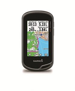
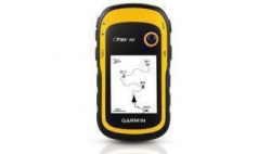
Magellan Meridian Color Handheld GPS Navigator (16 MB)
Meridian Color 980598-18 – Meridian Color handheld color GPS – 16 MB built-in mapping database of North America (highways, major roads, parks, waterways, airports, cities and marine navigation aids, such as buoys, obstructions, wrecks, lighthouses, etc.)- Large, high contrast, high color 120 x 160 pixel backlit display (LCD dimensions: 1.5″ x 2″)- Finds your location by tracking up to 12 GPS satellites simultaneously- Assisted by the U.S. Wide Area Augmentation System (WAAS)- Accurate to within 3 meters or better- Large keyboard – Street-level maps downloadable on an optional Magellan SD memory card- 9 Customizable graphic navigation displays show a map, compass, speedometer, and text readouts of heading, bearing, speed, direction, ETA, and more – 12 Built-in coordinate systems- 76 Datums including latitude/longitude, universal transverse mercator, and military grid reference system- Store up to 20 routes, 500 waypoints and 2,000 track-points – Save track-to-route (convert complicated track files into easy to follow routes, save hundreds of routes by transferring them to a PC with Magellan MapSend software)- NorthFinder (shows your direction even when standing still)- Shows you when the sun will rise and set, as well as the phase of the moon, for any date and location in the world- Fish and game calculator- Monitor the GPS satellites in view and get information about their status- 2 AA batteries provide up to 13 hours of continuous use- Rubber armored, impact resistant plastic – Waterproof (sealed to IEC-529 IPX7 specifications, also floats)- Built-in help database- Multiple language support (English, French, German, Swedish, Finnish, Spanish, Italian, Portuguese, Dutch)- Infinitely expandable with SD cards- Quadrifilar antenna- Connects easily to a PC via included PC cable- Silver and blackPackage Contents:- GPS color receiver- PC cable- 16MB built-in maps with navaids- Wrist strap- 2 AA bEarly Adopters Pick: January 2003. The first handheld GPS unit with a full-color screen.
The Magellan Meridian Color is the first handheld GPS receiver to feature a full-color screen. Find your way with superior tracking and accuracy to within three meters, a built-in mapping database, and a high-color, high-contrast, backlit, 120 x 160 pixel display. The Meridian Color finds your location by tracking up to 12 GPS satellites simultaneously, and is also assisted by the U.S. Wide Area Augmentation System (WAAS), so it’s accurate to within three meters or better.
The Meridian Color is ruggedly constructed and is waterproof, so you can take it anywhere, whether you’re navigating the streets or hitting the trails. It features nine customizable graphic navigation displays including a map, compass, and speedometer, and text readouts that show heading, bearing, speed, direction, ETA, and more. You can choose from 12 built-in coordinate systems and 76 datums including latitude/longitude, the Universal Transverse Mercator grid, and the Military Grid Reference System.
The Meridian Color features 16 MB of built-in maps of North America–including interstates, highways, major roads, waterways, cities, airports, and more–that you can also expand by downloading onto an optional Secure Digital memory card (not included). You can store up to 20 routes, 500 waypoints, and 2,000 track points, and the Save Track-to-Route feature allows you to convert complicated track files into easy-to-follow routes. Magellan MapSend software, available separately, lets you save hundreds of routes to your PC.
Other features include NorthFinder technology, which shows your direction even when standing still; sun and moon positions, which shows you when the sun will rise and set and the phase of the moon; a fish and game calculator, which shows you when the fish are likely to be biting in any location; and satellite status, which monitors the GPS satellites in view and gets information about their status.
Product Features
- Full-color 120 x 160 pixel display; backlit for easy night-time use
- Uses WAAS technology for accuracy to within 3 meters or better
- 16 MB of built-in memory includes mapping of North America and unlimited expandability
- Rubber armored construction is impact resistant and waterproof
- Runs for up to 13 hours on 2 AA batteries; includes USB interface with cable


What a Bringdown
color display too dark After losing an older Meridian Marine, I decided to make use of my software and buy this unit since I LOVED the previous model for a few years. When I received this model it seemed to be working fine when I initialized it. It came with antique version 4.02 firmware, marked from 2002. The unit refused all my software (specifically uploading REGIONS off the Topo, Nav, and World Basemap discs) until I upgraded the firmware to anything above v.5. When I tried to install v5.34 from the CD or v…
I bought one of these because it had a color display. After I received it I noticed the display was practically impossible to see unless the backlight was on high. I drove around with it a little and it tracked where I went very well but I had to leave the light on all the time and it ran the batteries down in about four hours. I was using Duracell 1800 nimh rechargables. I returned it the next day and got a Meridian platinum for less money and it has a barometer and thermometer. The…